This is gonna be a thread for working on the elevation (and perhaps some other things, such as tectonic plates as requested) for Loviniosa. I'm not sure if many people will be doing it, but I know a few (Fiah, Tuto?) who were willing to work on it. In any case, I'd ask that the people working on it can only be the people who's worked on the official USFM, so I apologize to anyone else. If you plan to work on it, please post here, and feel free (recommended) to discuss about it with other people who're working on it.
A basic rundown:
There are different layers within the file; the names of the countries, rivers, internal borders, and external borders. These will be able to help you coordinate locations if you need assistance in anything, and these won't be adjusted by anyone except by myself.
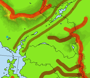
There's a layer for planned elevation, which is something like this:

The red streaks represent a major mountain chain, and the dark red/brownish color represents a minor mountain chain. The light brown color represents a rift valley, and the blue spots represent lakes (ignore this, though, as they'll be removed -- they were a placeholder for lakes).
The actual elevation file is below that. Some of it has been done -- for example, Bielosia, Pyxanovia, etc. have been done already, but the rest of the continent is uncompleted.
Below that are the basemap (blank) and the ocean.
* I haven't included a tectonic plate map because this is straight from my own personal file, not the official map's, so adjustments can be made, or a new one can be completely made. As a result, elevation will be made from them, so adjustments will have to be made with elevation as well.
If needed, the file can be converted to GIMP if you prefer that program.